APPENDICES
This section contains supplementary information.
A1. Example of Dependency Installation for Ubuntu 24.04 LTS
The example below uses the GNU compilers and Open MPI. Commands are issued as root user in the bash shell.:
##########################################################
###     Get libraries available through apt-get        ###
##########################################################

apt-get update

apt-get install wget bzip2 ca-certificates gfortran \
                libnetcdff-dev mpi-default-dev \
                cmake git netcdf-bin

##########################################################
###          Check netCDF installs (optional)          ###
##########################################################

nf-config --all
nc-config --all
A2. Exceptions for Running WRF-Hydro with the Noah LSM
Support for the Noah Land Surface Model (LSM) within WRF-Hydro is currently frozen at Noah version 3.6. Since the Noah LSM is not under active development by the community, WRF-Hydro is continuing to support Noah in deprecated mode only. Some new model features, such as the improved output routines, have not been setup to be backward compatible with Noah. Noah users should follow the guidelines below for adapting the WRF-Hydro workflow to work with Noah:
LSM initialization: The simple wrfinput.nc initialization file created by the create_Wrfinput.R script does not currently include all of the fields required by the Noah LSM. Therefore, Noah users should use the WRF real.exe utility to create a wrfinput_d0x file. Refer to the WRF documentation and user guides for information on how to do this.
Time-varying vegetation specifications: While the Noah LSM will be properly initialized with green vegetation fraction from the wrfinput file, there is currently no automated method to update this field over time (e.g., seasonally based on climatology). Therefore, Noah users will need to provide these time-varying fields in the model input forcing files (e.g., LDASIN).
Spatially varying parameters: Spatially varying soil and vegetation parameters (e.g., soil_properties.nc) are not supported in Noah.
Model outputs: The updated output routines have not been adapted to work with Noah. Therefore, Noah users should always use io_form_outputs = 0 to activate the deprecated output routines. Scale/offset and compression options, CF compliance, augmented spatial metadata, etc. are not available in this deprecated mode.
A3. Noah \(namelist.hrldas\) File with Description of Options
Below is an annotated namelist.hrldas file for running with the Noah land surface model. Notes and descriptions are indicated with <– and blue text.
&NOAHLSM_OFFLINE
HRLDAS_CONSTANTS_FILE = "./DOMAIN/wrfinput_d01" !!<-- Path to wrfinput file containing initialization data
! for the LSM. This is required even for a warm start
! where a restart file is provided.
INDIR = "./FORCING" !<-- Path to atmospheric forcing data directory.
OUTDIR = "./" !<-- Generally leave this as-is (output goes to base run directory);
! redirected output only applies to LSM output files and can cause
! issues when running coupled to WRF-Hydro.
START_YEAR = 2013 !<-- Simulation start year
START_MONTH = 09 !<-- Simulation start month
START_DAY = 01 !<-- Simulation start day
START_HOUR = 00 !<-- Simulation start hour
START_MIN = 00 !<-- Simulation start min
RESTART_FILENAME_REQUESTED = "RESTART.2013090100_DOMAIN1" !<-- Path to LSM restart file if using; this contains a
! "warm" model state from a previous model run.
! Comment out if not a restart simulation.
! Specification of simulation length in days hours
KHOUR = 24 !<-- Number of hours for simulation;
! Timesteps in units of seconds
FORCING_TIMESTEP = 3600 !<-- Timestep for forcing input data (in seconds)
NOAH_TIMESTEP = 3600 !<-- Timestep the LSM to cycle (in seconds)
OUTPUT_TIMESTEP = 86400 !<-- Timestep for LSM outputs, LDASOUT (in seconds)
! Land surface model restart file write frequency
RESTART_FREQUENCY_HOURS = 6 !<-- Timestep for LSM restart files to be generated (in hours). A value of -99999
! will simply output restarts on the start of each month, useful for longer
! model runs. Restart files are generally quite large, so be cognizant of
! storage space and runtime impacts when specifying.
! Split output after split_output_count output times.
SPLIT_OUTPUT_COUNT = 1 !<-- Number of timesteps to put in a single output file. This option
! must be 1 for NWM output configurations.
! Soil layer specification
NSOIL=4 !<-- Number of soil layers
ZSOIL(1) = 0.10 !<-- Thickness of top soil layer (m)
ZSOIL(2) = 0.30 !<-- Thickness of second soil layer (m)
ZSOIL(3) = 0.60 !<-- Thickness of third soil layer (m)
ZSOIL(4) = 1.00 !<-- Thickness of bottom soil layer (m)
! Forcing data measurement heights
ZLVL = 2.0 !<-- Height of input temperature and humidity measurement/estimate
ZLVL_WIND = 10.0 !<-- Height of input wind speed measurement/estimate
IZ0TLND = 0 !<-- Switch to control land thermal roughness length. Option 0 is the default,
! non-vegetation dependent value and option 1 introduces a vegetation dependence.
SFCDIF_OPTION = 0 !<-- Option to use the newer, option 1, or older,
option 0, SFCDIF routine. The default value is 0.
UPDATE_SNOW_FROM_FORCING = .FALSE. !<-- Option to activate or deactivate updating the snowcover
! fields from available analyses. The default option is true.
! -------- Section: Select atmospheric forcing input file format, FORC_TYP -------- !
! Specification of forcing data: 1=HRLDAS-hr format, 2=HRLDAS-min format,
! 3=WRF,4=Idealized, 5=Ideal w/ Spec.Precip.,
! 6=HRLDAS-hrly fomat w/ Spec. Precip, 7=WRF w/ Spec. Precip
FORC_TYP = 3
/
A4. Noah-MP \(namelist.hrldas\) File with Description of Options
Below is an annotated namelist.hrldas file for running with the Noah-MP
land surface model. Do note that the file says &NOAHLSM_OFFLINE
however it is for use with the Noah-MP LSM. This namelist statement
happens to be hardcoded and thus not easily changed. Notes and
descriptions are indicated with <– and blue text when after sections
being described. See the official HRLDAS namelist description here:
https://github.com/NCAR/hrldas-release/blob/release/HRLDAS/run/README.namelist
&NOAHLSM_OFFLINE
HRLDAS_SETUP_FILE = "./DOMAIN/wrfinput_d01" !<-- Path to wrfinput file containing initialization
                                            ! data for the LSM. This is required even for a warm
                                            ! start where a restart file is provided.
INDIR = "./FORCING" !<-- Path to atmospheric forcing data directory.

SPATIAL_FILENAME = "./DOMAIN/soil_properties.nc" !<-- Path to optional 2d/3d soil and vegetation
                                                 ! parameter file. If you are using this option,
                                                 ! you must also use a binary compiled with
                                                 ! SPATIAL_SOIL=1. If using the traditional
                                                 ! parameter lookup tables, compile with
                                                 ! SPATIAL_SOIL=0 and comment out this option.
OUTDIR = "./" !<-- Generally leave this as-is (output goes to base run directory); redirected
              ! output only applies to LSM output files
              ! and can cause issues when running coupled to WRF-Hydro.
START_YEAR = 2013 !<-- Simulation start year
START_MONTH = 09 !<-- Simulation start month
START_DAY = 12 !<-- Simulation start day
START_HOUR = 04 !<-- Simulation start hour
START_MIN = 00 !<-- Simulation start min
RESTART_FILENAME_REQUESTED = "RESTART.2013091204_DOMAIN1" !<-- Path to LSM restart file if using;
                                                          ! this contains a "warm" model state
                                                          ! from a previous model run. Comment out
                                                          ! if not a restart simulation.
! Specification of simulation length in days OR hours
KHOUR = 24 !<-- Number of hours for simulation

! -------- Following Section: Noah-MP physics options -------- !

! Physics options (see the documentation for details)

DYNAMIC_VEG_OPTION = 4
CANOPY_STOMATAL_RESISTANCE_OPTION = 1
BTR_OPTION = 1
RUNOFF_OPTION = 3
SURFACE_DRAG_OPTION = 1
FROZEN_SOIL_OPTION = 1
SUPERCOOLED_WATER_OPTION = 1
RADIATIVE_TRANSFER_OPTION = 3
SNOW_ALBEDO_OPTION = 2
PCP_PARTITION_OPTION = 1
TBOT_OPTION = 2
TEMP_TIME_SCHEME_OPTION = 3
GLACIER_OPTION = 2
SURFACE_RESISTANCE_OPTION = 4

! Timesteps in units of seconds
FORCING_TIMESTEP = 3600 !<-- Timestep for forcing input data (in seconds)
NOAH_TIMESTEP = 3600 !<-- Timestep the LSM to cycle (in seconds)
OUTPUT_TIMESTEP = 86400 !<-- Timestep for LSM outputs, LDASOUT (in seconds)

! Land surface model restart file write frequency
RESTART_FREQUENCY_HOURS = 2 !<-- Timestep for LSM restart files to be generated (in hours).
                            ! A value of -99999 will simply output restarts on the start of
                            ! each month, useful for longer model runs. Restart files are
                            ! generally quite large, so be cognizant of storage space and
                            ! runtime impacts when specifying.
! Split output after split_output_count output times.
SPLIT_OUTPUT_COUNT = 1 !<-- Number of timesteps to put in a single
output file. This option must be 1 for NWM output configurations.

! Soil layer specification
NSOIL=4 !<-- Number of soil layers
soil_thick_input(1) = 0.10 !<-- Thickness of top soil layer (m)
soil_thick_input(2) = 0.30 !<-- Thickness of second soil layer (m)
soil_thick_input(3) = 0.60 !<-- Thickness of third soil layer (m)
soil_thick_input(4) = 1.00 !<-- Thickness of bottom soil layer (m)

! Forcing data measurement height for winds, temp, humidity
ZLVL = 10.0 !<-- Height of input wind speed

! -------- Following Section: Restart IO file formats -------- !

! Options to specify whether restart files (both read in and output)
! should be in binary or netCDF format. Generally recommend using
! netCDF format (option 0) for both.

! Restart file format options
rst_bi_in = 0  !<-- 0: use netcdf input restart file 1: use parallel io for reading multiple
               ! restart files (1 per core)
rst_bi_out = 0 !<-- 0: use netcdf output restart file 1: use parallel io for outputting multiple
               ! restart files (1 per core)
/

&WRF_HYDRO_OFFLINE

! Specification of forcing data: 1=HRLDAS-hr format, 2=HRLDAS-min format,
! 3=WRF, 4=Idealized, 5=Ideal w/ Spec.Precip.,
! 6=HRLDAS-hrly fomat w/ Spec. Precip, 7=WRF w/ Spec.Precip
FORC_TYP = 1
/
A5. WRF-Hydro \(hydro.namelist\) File with Description of Options
Below is an annotated hydro.namelist file. Annotations follow what is being described, indicated with <– and blue text. Note that annotations describing options are meant to accompany the commented description in the namelist which precedes the option.
&HYDRO_nlist
!!!! --------------- SYSTEM COUPLING -------------- !!!!
! Specify what is being coupled: 1=HRLDAS (offline Noah-LSM),
! 2=WRF, 3=NASA/LIS, 4=CLM
sys_cpl = 1 !<-- For offline runs, including Noah and NoahMP, this will be option 1.

!!!! ----------- MODEL INPUT DATA FILES ----------- !!!!
! Specify land surface model gridded input data file (e.g.: "geo_em.d01.nc")
GEO_STATIC_FLNM = "./DOMAIN/geo_em.d01.nc" !<-- Path to the “GEOGRID” file which contains base
                                           ! information on the LSM grid (this file is generally
                                           ! created via WPS in the model preprocessing steps).

! Specify the high-resolution routing terrain input data file (e.g.: "Fulldom_hires.nc")
GEO_FINEGRID_FLNM = "./DOMAIN/Fulldom_hires.nc" !<-- Path to the “routing stack” which contains
                                                ! base information on the high-resolution routing
                                                ! grid. This file is generally created via the
                                                ! GIS pre-processing tools.

! Specify the spatial hydro parameters file (e.g.: "hydro2dtbl.nc")
! If you specify a filename and the file does not exist, it will
! be created for you.
HYDROTBL_F = "./DOMAIN/hydro2dtbl.nc" !<-- Path to the new 2d hydro parameters file. If this file
                                      ! does not exist, it will be created for you based on
                                      ! HYDRO.TBL and the soil and land class grids foundin the
                                      ! GEOGRID netCDF file

! Specify spatial metadata file for land surface grid. (e.g.: "GEOGRID_LDASOUT_Spatial_Metadata.nc")
LAND_SPATIAL_META_FLNM = "./DOMAIN/GEOGRID_LDASOUT_Spatial_Metadata.nc" !<-- Path to the geospatial
                                             ! metadata file for your domain. This file is required
                                             ! if using any of the io_form_outputs options (i.e.,
                                             ! io_form_outputs > 0). This file is generally created
                                             ! via the GIS pre-processing tools.

! Specify the name of the restart file if starting from restart...comment out with '!' if not...
RESTART_FILE = 'HYDRO_RST.2013-09-12_04:00_DOMAIN3' !<-- Path to hydro restart file; this contains
                                                    ! a "warm" model state from a previous model run.

!!!! ------------- MODEL SETUP OPTIONS ------------ !!!!
! Specify the domain or nest number identifier...(integer)
IGRID = 1 !<-- Domain ID number. This comes from the WRF coupling framework and is intended to
          ! specify which nested domain you are running. For standalone runs, this is not relevant
          ! HOWEVER this ID must match the number specified after DOMAIN in your forcing file names
          ! (e.g., the "1" in "2013091200.LDASIN_DOMAIN1").

! Specify the restart file write frequency in minutes
! A value of -99999 will output restarts on the first day of the month only.
rst_dt = 120 !<-- Specify how often hydro restart files should be generated, in minutes. This should
             ! generally track your LSM restart file frequency (as specified in namelist.hrldas).
             ! A value of -99999 will simply output restarts on the start of each month, useful for
             ! longer model runs. Hydro restart files are generally quite large, so be cognizant of
             ! storage space and runtime impacts.

! Reset the LSM soil states from the high-res routing restart file (1=overwrite, 0=no overwrite)
! NOTE: Only turn this option on if overland or subsurface routing is active!
rst_typ = 1 !<-- Specify whether or not to use the soil conditions (soil moisture and ponded water)
            ! from the high-resolution hydro restart file, if "warm" starting the model with a
            ! provided HYDRO_RST file. If this option is 0, the LSM restart states will be used
            ! instead. IMPORTANT: If you are NOT running with terrain routing turned on, do not set
            ! this option to 1 as it may bring in invalid values.

! Restart file format control !<-- Options to whether restart files (input and output separately)
                              ! should be in binary or netCDF format. Generally recommend to use
                              ! netCDF format (option 0) for both.
rst_bi_in = 0 !0: use netCDF input restart file (default) 1: use parallel io for reading multiple
              ! restart files, 1 per core
rst_bi_out = 0 !0: use netCDF output restart file (default) 1: use parallel io for outputting multiple
               ! restart files, 1 per core

! Restart switch to set restart accumulation variables to 0 (0=no reset, 1=yes reset to 0.0)
RSTRT_SWC = 0 !<-- Specify whether or not to reset any accumulated output variables to 0 (option 1)
              ! or to continue accumulating from the values in the hydro restart file (option 0).
              ! Note that this only applies to the hydrologic model outputs; the LSM outputs will
              ! always continue to accumulate from the LSM restart file.

! Specify baseflow/bucket model initialization (0=cold start from table, 1=restart file)
GW_RESTART = 1 !<-- Specify whether to initialize the groundwater bucket states from the hydro
               ! restart file (option 1) or "cold" start the bucket states from the parameter
               ! table, GWBUCKPARM.nc.

!!!! ------------ MODEL OUTPUT CONTROL ------------ !!!!
! Specify the output file write frequency...(minutes)
out_dt = 60 !<-- Timestep for hydro model outputs, in minutes. This covers all output options
            ! listed below (CHRTOUT, GWOUT, RTOUT, LAKEOUT, etc.) so be cognizant of impacts
            ! on disk space and runtime when specifying.

! Specify the number of output times to be contained within each output history file...(integer)
! SET = 1 WHEN RUNNING CHANNEL ROUTING ONLY/CALIBRATION SIMS!!!
! SET = 1 WHEN RUNNING COUPLED TO WRF!!!
SPLIT_OUTPUT_COUNT = 1 !<-- Number of timesteps to put in a single output file.

! Specify the minimum stream order to output to netCDF point file (integer)
! Note: lower value of stream order produces more output.
order_to_write = 4 !<-- Lowest stream order to include in output files. Selecting 1 gives
                   ! you output for every reach/channel cell, selecting a higher order number
                   ! gives you fewer channel output elements.

! Flag to turn on/off new I/O routines:
! 0 = deprecated output routines (only use when running with the Noah LSM),
! 1 = with scale/offset/compression,
! 2 = with scale/offset/NO compression,
! 3 = compression only,
! 4 = no scale/offset/compression (default)
io_form_outputs = 1 !<-- Specify which output option to use (NOTE: option 0 is the only
                  ! supported option when running with the original Noah LSM)

! Realtime run configuration option:
! 0=all (default), 1=analysis, 2=short-range, 3=medium-range,
! 4=long-range, 5=retrospective,
! 6=diagnostic (includes all of 1-4 outputs combined)
io_config_outputs = 1 !<-- Specify which configuration of output variables to generate
                      ! (NOTE: not active when io_form_outputs=0)

! Option to write output files at time 0 (restart cold start time): 0=no, 1=yes (default)
t0OutputFlag = 1 !<-- Select whether or not to create outputs at the initial timestep.

! Options to output channel & bucket influxes. Only active for UDMP_OPT=1.
! Nonzero choice requires that out_dt above matches NOAH_TIMESTEP in namelist.hrldas.
! 0=None (default), 1=channel influxes (qSfcLatRunoff, qBucket)
! 2=channel+bucket fluxes (qSfcLatRunoff, qBucket, qBtmVertRunoff_toBucket)
! 3=channel accumulations (accSfcLatRunoff, accBucket) *NOT TESTED*
output_channelBucket_influx = 0 !<-- Select which additional channel and groundwater bucket
                                ! outputs will be generated. These additional variables can
                                ! be used to drive the channel-only model.

! Output netCDF file control - specify which outputs to generate for the run.

CHRTOUT_DOMAIN = 1 !<-- Channel output variables (streamflow, velocity, head, etc.) as a netCDF
                   ! point timeseries output at all channel points (1d) 0 = no output, 1 = output

CHANOBS_DOMAIN = 0 !<-- NetCDF point timeseries at forecast points or gage points (defined in
                   ! Route_Link.nc) 0 = no output, 1 = output

CHRTOUT_GRID = 0 !<-- NetCDF grid of channel streamflow values (2d) 0 = no output, 1 = output
                 ! NOTE: Not available with reach-based routing

LSMOUT_DOMAIN = 0 !<-- NetCDF grid of variables passed between LSM and routing components (2d)
                  ! (generally used for diagnostics only)
                  ! 0 = no output, 1 = output NOTE: No scale_factor/add_offset available

RTOUT_DOMAIN = 1 !<-- NetCDF grid of terrain routing variables on routing grid (2d)
               ! 0 = no output, 1 = output

output_gw = 1 !<-- NetCDF groundwater output, 0 = no output, 1 = output
              ! Groundwater bucket outputs [level, inflow, outflow]

outlake = 1 !<-- NetCDF grid of lake values (1d) 0 = no output, 1 = output !
            ! Lake output variables (if lakes are included in the domain) [level, inflow, outflow]

frxst_pts_out = 0 !<-- ASCII text file of streamflow at forecast points or gage points
                  ! (defined in Route_Link.nc),  0 = no output, 1 = output

!!!! ---- PHYSICS OPTIONS AND RELATED SETTINGS ---- !!!!

! Specify the number of soil layers (integer) and the depth of the bottom of each layer... (meters)
! Notes: In the current version of WRF-Hydro these must be the same as in the namelist.input file.
! Future versions may permit this to be different.
NSOIL=4 !<-- Number of soil layers
ZSOIL8(1) = -0.10 !<-- Depth of bottom boundary of top soil layer in meters
ZSOIL8(2) = -0.40 !<-- Depth of bottom of second soil layer in meters (note that this is specified
                  ! differently than the namelist.hrldas; this is total depth from the surface
                    instead of thickness)
ZSOIL8(3) = -1.00 !<-- Depth of bottom of third soil layer in meters (note that this is specified
                  ! differently than the namelist.hrldas; this is total depth from the surface
                    instead of thickness)
ZSOIL8(4) = -2.00 !<-- Depth of bottom of fourth (last) soil layer in meters (note that this is
                  ! specified differently than the namelist.hrldas; this is total depth from the
                    surface instead of thickness)

! Specify the grid spacing of the terrain routing grid (meters)
DXRT = 100.0 !<-- Resolution of the high-res routing grid
! Specify the integer multiple between the land model grid and the terrain routing grid (integer)
AGGFACTRT = 10 !<-- Aggregation factor between the high-res routing grid and the LSM grid;
               ! e.g., a 100-m routing grid resolution and a 1km LSM grid resolution would
               ! be AGGFACTRT = 10.

! Specify the channel routing model timestep (seconds)
DTRT_CH = 10 !<-- Timestep for the channel routing module to cycle, in seconds; model runtime
             ! will be sensitive to this timestep, so choose something appropriate for your
             ! domain resolution (finer resolutions generally require finer timesteps).
! Specify the terrain routing model timestep (seconds)
DTRT_TER = 10 !<-- Timestep for the terrain routing module to cycle, in seconds; model runtime
              ! will be sensitive to this timestep, so choose something appropriate for your
              ! domain resolution (finer resolutions generally require finer timesteps).

! Switch to activate subsurface routing...(0=no, 1=yes)
SUBRTSWCRT = 1 !<-- Turn on/off subsurface routing module.
! Switch to activate surface overland flow routing...(0=no, 1=yes)
OVRTSWCRT = 1 !<-- Turn on/off overland routing module.

! Specify overland flow routing option:
! 1=Seepest Descent (D8) 2=CASC2D (not active)
! NOTE: Currently subsurface flow is only steepest descent
rt_option = 1 !<-- For both terrain routing modules, specify whether flow should follow the
              ! steepest path (option 1) or multi-directional (option 2).
              ! Option 2 is currently unsupported.

! Switch to activate channel routing...(0=no, 1=yes)
CHANRTSWCRT = 1 !<-- Turn on/off channel routing module.

! Specify channel routing option:
! 1=Muskingam-reach, 2=Musk.-Cunge-reach, 3=Diff.Wave-gridded
channel_option = 3 !<-- If channel routing module is active, select which physics option to use.

! Specify the reach file for reach-based routing options (e.g.: "Route_Link.nc")
route_link_f = "./DOMAIN/Route_Link.nc" !<-- If using one of the reach-based channel routing
                                        ! options (channel_option = 1 or 2), specify the path
                                        ! to the Route_Link.nc file, which provides the
                                        ! channel-reach parameters.

! If using channel_option=2, activate the compound channel formulation? (Default=.FALSE.)
! This option is currently only supported if using reach-basedrouting with UDMP=1.
compound_channel = .FALSE.

! Specify the lake parameter file (e.g.: "LAKEPARM.nc"). Note: REQUIRED if lakes are on.
route_lake_f = "./DOMAIN/LAKEPARM.nc" !<-- If lakes are active,specify the path to the lake
                                      !  parameter file, which provides thelake parameters.

! Switch to activate baseflow bucket model…
! (0=none, 1=exp. bucket, 2=pass-through)
GWBASESWCRT = 1 !<-- Turn on/off the ground water bucket module. Option 1 activates the
                ! exponential bucket model, Option 2 bypasses the bucket model and dumps all
                ! flow from the bottom of the soil column directly into the channel, and
                ! Option 0 creates a sink at the bottom of the soil column (water draining from
                ! the bottom of the soil column leaves the system, so note that this option will
                ! not have water balance closure).

! Groundwater/baseflow 2d mask specified on land surface model grid (e.g.: "GWBASINS.nc").
! NOTE: Only required if baseflow model is active (1 or 2) and UDMP_OPT=0.
gwbasmskfil = "./DOMAIN/GWBASINS.nc" !<-- For configurations wherethe bucket or pass-through
                                     ! groundwater modules are active, provide the path to the
                                     ! 2d netCDF file (LSM grid resolution) that maps the
                                     ! groundwater basin IDs. Bucket parameters will be specified
                                     ! through the GWBUCKPARM.nc file, whose IDs should match
                                     ! those in the groundwater basin mask file.

! Groundwater bucket parameter file (e.g.: "GWBUCKPARM.nc")
GWBUCKPARM_file = "./DOMAIN/GWBUCKPARM.nc" !<-- For configurations where the groundwater bucket
                                           ! model is active, specify the path to the bucket
                                           ! parameter file, which provides bucket parameters
                                           ! by catchment.

! User defined mapping, such NHDPlus: 0=no (default), 1=yes
UDMP_OPT = 0 !<-- If 1, this tells the model to use a "user-defined mapping" scheme to translate
             ! between terrain and groundwater flow and reaches, e.g., NHDPlus.
! If UDM is on, specify the user-defined mapping file (e.g.: "spatialweights.nc")
!udmap_file = "./DOMAIN/spatialweights.nc" !<-- If UDMP_OPT=1 (user defined mapping is active),
                                           ! provide the path to the required spatial weights
                                           ! file, which maps between grid cells and catchments.

/ !<-- End of hydro namelist HYDRO_nlist

&NUDGING_nlist !<-- Start of separate namelist for nudging, only used if the model is compiled
               ! with the compile-time option WRF_HYDRO_NUDGING=1. Ignored otherwise.

! Path to the "timeslice" observation files.
timeSlicePath = "./nudgingTimeSliceObs/" !<-- Path to a directory containing nuding “time slice”
                                         ! observation files. There are no requirements on the
                                         ! existence of files in the directory, but the directory
                                         ! itself must exist if specified.
nudgingParamFile = "DOMAIN/nudgingParams.nc" !<-- Path to the required nudging parameter file.
! Nudging restart file. nudgingLastObsFile defaults to '', which will look for
! nudgingLastObs.YYYY-mm-dd_HH:MM:SS.nc *AT THE INITALIZATION TIME OF THE RUN*. Set to a missing
! file to use no restart.
!nudgingLastObsFile = '/a/nonexistent/file/gives/nudging/cold/start' !<-- Optional path to an
                                                                     ! optional nudging restart
                                                                     ! file. See comments above.
! Parallel input of nudging timeslice observation files?
readTimesliceParallel = .TRUE. !<-- Can read the observation files in parallel (on different cores)
                               ! for quicker run speeds.

! temporalPersistence defaults to true, only runs if necessary params present.
temporalPersistence = .FALSE. !<-- This option uses the expCoeff
                              ! parameter for persisting observations

! The total number of last (obs, modeled) pairs to save in nudgingLastObs for removal of bias.
! This is the maximum array length. (This option is active when persistBias=FALSE)
! (Default=960=10days @15min obs resolution, if all the obs are present and longer if not.)
nLastObs = 960 !<-- The maximum trailing window size for calculating bias correction.

! If using temporalPersistence the last observation persists by default. This option instead
! persists the bias after the last observation.
persistBias = .FALSE. !<-- Apply bias correction as observations move into the past?
                      ! AnA (FALSE) vs Forecast (TRUE) bias persistence.

! If persistBias: Does the window for calculating the bias end at model init time (=t0)?
! FALSE = window ends at model time (moving),
! TRUE = window ends at init=t0(fcst) time.
! (If commented out, Default=FALSE)
! Note: Perfect restart tests require this option to be .FALSE.
biasWindowBeforeT0 = .FALSE. !<-- Is the bias window shifting with
                             ! model integration?

! If persistBias: Only use this many last (obs, modeled) pairs.
! (If Commented out, Default=-1*nLastObs)
! > 0: apply an age-based filter, units=hours.
! = 0: apply no additional filter, use all available/usable obs.
! < 0: apply an count-based filter, units=count
maxAgePairsBiasPersist = -960

! If persistBias: The minimum number of last (obs, modeled) pairs, with age less
! than maxAgePairsBiasPersist, required to apply a bias correction. (default=8)
minNumPairsBiasPersist = 8

! If persistBias: give more weight to observations closer in time? (default=FALSE)
invDistTimeWeightBias = .TRUE. !<-- The exact form of this
                               ! weighting is currently hard-coded.

! If persistBias: "No constructive interference in bias correction?", reduce the bias
! adjustment when the model and the bias adjustment have the same sign relative to the
! modeled flow at t0? (default=FALSE)
! Note: Perfect restart tests require this option to be .FALSE.
noConstInterfBias = .FALSE. !<-- Tactical response to phase errors.
/
A6. Noah land surface model parameter tables
The Noah land surface model requires three parameter table files denoted by the file suffix TBL. The variables contained within these files are described in the tables below.
Please refer to the Noah land surface model documentation (https://ral.ucar.edu/sites/default/files/public/product-tool/unified-noah-lsm/Noah_LSM_USERGUIDE_2.7.1.pdf) for additional information.
\(GENPARM.TBL\) - This file contains global parameters for the Noah land surface model.
Variable name |
Description |
|---|---|
SLOPE_DATA |
Linear reservoir coefficient |
SBETA_DATA |
Parameter used to calculate vegetation effect on soil heat |
FXEXP_DAT |
Soil evaporation exponent used in DEVAP |
CSOIL_DATA |
Soil heat capacity [\(J/m^3/K\)] |
SALP_DATA |
Shape parameter of distribution function of snow cover |
REFDK_DATA |
Parameter in the surface runoff parameterization |
REFKDT_DATA |
Parameter in the surface runoff parameterization |
FRZK_DATA |
Frozen ground parameter |
ZBOT_DATA |
Depth of lower boundary soil temperature [\(m\)] |
CZIL_DATA |
Parameter used in the calculation of the roughness length for heat |
SMLOW_DATA |
Soil moisture wilt, soil moisture reference parameter |
SMHIGH_DATA |
Soil moisture wilt, soil moisture reference parameter |
LVCOEF_DATA |
Parameter in the snow albedo formulation |
Variable name |
Description |
|---|---|
BB |
B parameter |
DRYSMC |
Dry soil moisture threshold at which direct evaporation from top soil layer ends |
F11 |
Soil thermal diffusivity/conductivity coefficient |
MAXSMC |
Saturation soil moisture content (i.e. porosity) |
REFSMC |
Reference soil moisture (field capacity), where transpiration begins to stress |
SATPSI |
Saturation soil matric potential |
SATDK |
Saturation soil conductivity |
SATDW |
Saturation soil diffusivity |
WLTSMC |
Wilting point soil moisture |
QTZ |
Soil quartz content |
Variable name |
Description |
|---|---|
SHDFAC |
Green vegetation fraction |
NROOT |
Number of soil layers (from the top) reached by vegetation roots |
RS |
Minimum stomatal resistance [\(s/m\)] |
RGL |
Parameter used in radiation stress function |
HS |
Parameter used in vapor pressure deficit function |
SNUP |
Threshold water-equivalent snow depth [m] that implies 100% snow cover |
MAXALB |
Upper bound on maximum albedo over deep snow [\(\%\)] |
LAIMIN |
Minimum leaf area index through the year [dimensionless] |
LAIMAX |
Maximum leaf area index through the year [dimensionless] |
EMISSMIN |
Minimum background emissivity through the year [fraction 0.0 to 1.0] |
EMISSMAX |
Maximum background emissivity through the year [fraction 0.0 to 1.0] |
ALBEDOMIN |
Minimum background albedo through the year [fraction 0.0 to 1.0] |
ALBEDOMAX |
Maximum background albedo through the year [fraction 0.0 to 1.0] |
Z0MIN |
Minimum background roughness length through the year [\(m\)] |
Z0MAX |
Maximum background roughness length through the year [\(m\)] |
TOPT_DATA |
Optimum transpiration air temperature [\(K\)] |
CMCMAX_DATA |
Maximum canopy water capacity [volumetric fraction] |
CFACTR_DATA |
Parameter used in the canopy interception calculation [dimensionless] |
RSMAX_DATA |
Maximal stomatal resistance [\(s/m\)] |
BARE |
The land-use category representing bare ground (used to set the vegetation fraction to zero) [land-use category index] |
NATURAL |
The land-use category representative of the non-urban portion of urban land-use points [land-use category index] |
A7. Noah-MP land surface model parameter tables
The Noah-MP land surface model requires three parameter table files denoted by the file suffix TBL. The variables contained within these files are described in the tables below.
As part of the work conducted for the National Water Model
implementation, the ability to specify a number of these land surface
model parameters spatially on a two or three dimensional grid was
introduced. This is done through the use of the compile time option
SPATIAL_SOIL and the specification of a netCDF format parameter file
with the default filename soil_properties.nc. A list of the variables
contained in this file is included in a table below as well.
\(GENPARM.TBL\) This file contains global parameters for the Noah-MP land surface model.
Variable name |
Description |
|---|---|
SLOPE_DATA |
Linear reservoir coefficient |
SBETA_DATA |
Parameter used to calculate vegetation effect on soil heat |
FXEXP_DAT |
Soil evaporation exponent used in DEVAP |
CSOIL_DATA |
Soil heat capacity [\(J/m^3/K\)] |
SALP_DATA |
Shape parameter of distribution function of snow cover |
REFDK_DATA |
Parameter in the surface runoff parameterization |
REFKDT_DATA |
Parameter in the surface runoff parameterization |
FRZK_DATA |
Frozen ground parameter |
ZBOT_DATA |
Depth of lower boundary soil temperature [\(m\)] |
CZIL_DATA |
Parameter used in the calculation of the roughness length for heat |
SMLOW_DATA |
Soil moisture wilt, soil moisture reference parameter |
SMHIGH_DATA |
Soil moisture wilt, soil moisture reference parameter |
LVCOEF_DATA |
Parameter in the snow albedo formulation |
\(SOILPARM.TBL\) - This file contains parameters that are assigned based on soil classification.
Variable name |
Description |
|---|---|
BB |
B parameter |
DRYSMC |
Dry soil moisture threshold at which direct evaporation from top soil layer ends |
F11 |
Soil thermal diffusivity/conductivity coefficient |
MAXSMC |
Saturation soil moisture content (i.e. porosity) |
REFSMC |
Reference soil moisture (field capacity), where transpiration begins to stress |
SATPSI |
Saturation soil matric potential |
SATDK |
Saturation soil conductivity |
SATDW |
Saturation soil diffusivity |
WLTSMC |
Wilting point soil moisture |
QTZ |
Soil quartz content |
\(MPTABLE.TBL\) - This file contains parameters that are a function of land cover type.
Variable name |
Description |
|---|---|
VEG_DATASET_DESCRIPTION |
Land cover classification dataset |
NVEG |
Number of land cover categories |
ISURBAN |
Land cover category for urban |
ISWATER |
Land cover category for water |
ISBARREN |
Land cover category for barren |
ISICE |
Land cover category for ice |
EBLFOREST |
Land cover category for evergreen broadleaf forest |
Parameters below are a function of land cover type |
|
CH2OP |
Maximum intercepted H2O per unit LAI + SAI [\(mm\)] |
DLEAF |
Characteristic leaf dimension [\(m\)] |
Z0MVT |
Momentum roughness length [\(m\)] |
HVT |
Top of canopy [\(m\)] |
HVB |
Bottom of canopy [\(m\)] |
DEN |
Tree density [\(trunks/m^2\)] |
RC |
Tree crown radius [\(m\)] |
MFSNO |
Snowmelt m parameter |
RHOS_VIS |
Monthly stem area index (SAI), one-sided |
RHOS_NIR |
Monthly leaf area index (LAI), one-sided |
TAUL_VIS |
Leaf transmittance, visible |
TAUL_NIR |
Leaf transmittance, near infrared |
TAUS_VIS |
Stem transmittance, visible |
TAUS_NIR |
Stem transmittance, near infrared |
XL |
Leaf / stem orientation index |
CWPVT |
Canopy wind parameter |
C3PSN |
Photosynthetic pathway [c4 = 0. | c3 = 1.] |
KC25 |
CO2 Michaelis-Menten constant at 25°C [\(Pa\)] |
AKC |
Q10 for KC25 |
KO25 |
O2 Michaelis-Menten constant at 25°C [\(Pa\)] |
AKO |
Q10 for KO25 |
AVCMX |
Q10 for VCMX25 |
AQE |
Q10 for QE25 |
LTOVRC |
Leaf turnover [\(1/s\)] |
DILEFC |
Coefficient for leaf stress death [\(1/s\)] |
DILEFW |
Coefficient for leaf stress death [\(1/s\)] |
RMF25 |
Leaf maintenance respiration at 25°C [\(umol\ CO_{2}/m^2/s\)] |
SLA |
Single-side leaf area [\(m2/kg\)] |
FRAGR |
Fraction of growth respiration |
TMIN |
Minimum temperature for photosynthesis [\(K\)] |
VCMX25 |
maximum rate of carboxylation at 25°C [\(umol\ CO_{2}/m^2/s\)] |
TDLEF |
Characteristic temperature for leaf freezing [\(K\)] |
BP |
Minimum leaf conductance [\(umol\ /m^2/s\)] |
MP |
Slope of conductance to photosynthesis relationship |
QE25 |
Quantum efficiency at 25°C [\(umol\ CO_{2} / umol\ photon\)] |
RMS25 |
Stem maintenance respiration at 25°C [\(umol\ CO_{2}/kg_{bio}/s\)] |
RMR25 |
Root maintenance respiration at 25°C [\(umol\ CO_{2}/kg_{bio}/s\)] |
ARM |
Q10 for maintenance respiration |
FOLNMX |
Foliage nitrogen concentration when \(f(n)=1\) [\(\%\)] |
WRRAT |
Wood to non-wood ratio |
MRP |
Microbial respiration parameter [\(umol\ CO_{2}/kg_{C}/s\)] |
NROOT |
Number of soil layers with root present |
RGL |
Parameter used in radiation stress function |
RS |
Stomatal resistance [\(s/m\)] |
HS |
Parameter used in vapor pressure deficit function |
TOPT |
Optimum transpiration air temperature [K] |
RSMAX |
Maximal stomatal resistance [\(s m-1\)] |
SAI |
Steam area index |
LAI |
Leaf area index |
SLAREA |
(not used in Noah-MP as configured in WRF-Hydro) |
EPS1 |
(not used in Noah-MP as configured in WRF-Hydro) |
EPS2 |
(not used in Noah-MP as configured in WRF-Hydro) |
EPS3 |
(not used in Noah-MP as configured in WRF-Hydro) |
EPS4 |
(not used in Noah-MP as configured in WRF-Hydro) |
EPS5 |
(not used in Noah-MP as configured in WRF-Hydro) |
Parameters below are a function of soil color index |
|
ALBSAT_VIS |
Saturated soil albedos for visible |
ALBSAT_NIR |
Saturated soil albedos for near infrared |
ALBDRY_VIS |
Dry soil albedos for visible |
ALBDRY_NIR |
Dry soil albedos for near infrared |
Parameters below are global |
|
ALBICE |
Albedo land ice (visible and near infrared) |
ALBLAK |
Albedo frozen lakes (visible and near infrared) |
OMEGAS |
Two-stream parameter for snow |
BETADS |
Two-stream parameter for snow |
BETAIS |
Two-stream parameter for snow |
EG |
Emissivity soil surface (soil and lake) |
CO2 |
CO2 partial pressure |
O2 |
O2 partial pressure |
TIMEAN |
Grid cell mean topographic index [global mean] |
FSATMX |
Maximum surface saturated fraction [global mean] |
Z0SNO |
Snow surface roughness length [\(m\)] |
SSI |
Liquid water holding capacity for snowpack [\(m^3/m^3\)] |
SWEMX |
New snow mass to fully cover old snow [\(mm\)] |
TAU0 |
Tau0 from Yang97 eqn. 10a |
GRAIN_GROWTH |
Growth from vapor diffusion Yang97 eqn. 10b |
EXTRA_GROWTH |
Extra growth near freezing Yang97 eqn. 10c |
DIRT_SOOT |
Dirt and soot term Yang97 eqn. 10d |
BATS_COSZ |
Zenith angle snow albedo adjustment; b in Yang97 eqn. 15 |
BATS_VIS_NEW |
New snow visible albedo |
BATS_NIR_NEW |
New snow NIR albedo |
BATS_VIS_AGE |
Age factor for diffuse visible snow albedo Yang97 eqn. 17 |
BATS_NIR_AGE |
Age factor for diffuse NIR snow albedo Yang97 eqn. 18 |
BATS_VIS_DIR |
Cosz factor for direct visible snow albedo Yang97 eqn. 15 |
BATS_NIR_DIR |
Cosz factor for direct NIR snow albedo Yang97 eqn. 16 |
RSURF_SNOW |
Surface resistance for snow [\(s/m\)] |
RSURF_EXP |
Exponent in the shape parameter for soil resistance option 1 |
\(soil\_properties.nc\) [optional]
Variable name |
Description |
|---|---|
bexp |
Beta parameter |
cwpvt |
Empirical canopy wind parameter |
dksat |
Saturated soil hydraulic conductivity |
dwsat |
Saturated soil hydraulic diffusivity |
hvt |
Top of vegetation canopy [\(m\)] |
mfsno |
Snowmelt m parameter |
mp |
Slope of conductance to photosynthesis relationship |
psisat |
Saturated soil matric potential |
quartz |
Soil quartz content |
refdk |
Parameter in the surface runoff parameterization |
refkdt |
Parameter in the surface runoff parameterization |
rsurf_exp |
Exponent in the shape parameter for soil resistance option 1 |
slope |
Slope index |
smcdry |
Dry soil moisture threshold where direction evaporation from the top layer ends |
smcmax |
Saturated value of soil moisture [volumetric] |
smcref |
Reference soil moisture (field capacity) [volumetric] |
smcwlt |
Wilting point soil moisture [volumetric] |
vcmx25 |
Maximum rate of carboxylation at 25°C [\(umol\ CO_{2}/m^2/s\)] |
A8. Terrain routing parameter files
Parameters for the lateral routing component of WRF-Hydro are specified via either the \(HYDRO.TBL\) file or the \(hydro2dtbl.nc\) file. Variables within these files are described in the tables below.
\(HYDRO.TBL\)
Variable name |
Description |
|---|---|
The parameter below is a function of land cover type |
|
SFC_ROUGH |
Overland flow roughness coefficient |
The parameters below are a function of soil class |
|
SATDK |
Saturated soil hydraulic conductivity [\(m/s\)] |
MAXSMC |
Maximum volumetric soil moisture [\(m^3/m^3\)] |
REFSMC |
Reference volumetric soil moisture [\(m^3/m^3\)] |
WLTSMC |
Wilting point volumetric soil moisture [\(m^3/m^3\)] |
QTZ |
Quartz fraction of the soil |
\(hydro2dtbl.nc\)
Variable name |
Description |
|---|---|
SMCMAX1 |
Maximum volumetric soil moisture [\(m^3/m^3\)] |
SMCREF1 |
Reference volumetric soil moisture [\(m^3/m^3\)] |
SMCWLT1 |
Wilting point volumetric soil moisture [\(m^3/m^3\)] |
OV_ROUGH2D |
Overland flow roughness coefficient |
LKSAT |
Lateral saturated soil hydraulic conductivity [\(m/s\)] |
A9. Channel routing parameter tables (\(CHANPARM.TBL\) and \(Route\_Link.nc\))
Variables of the the channel routing parameter tables are described in the tables below.
Variable name |
Description |
|---|---|
Bw |
Channel bottom width [\(m\)] |
HLINK |
Initial depth of water in the channel [\(m\)] |
ChSSlp |
Channel side slope [\(m/m\)] |
MannN |
Manning’s roughness coefficient |
Variable name |
Description |
|---|---|
BtmWdth |
Channel bottom width [\(m\)] |
ChSlp |
Channel side slope [\(m/m\)] |
Kchan |
Channel conductivity [\(mm/hr\)] |
Length |
Stream segment length [\(m\)] |
MusK |
Muskingum routing time [\(s\)] |
MusX |
Muskingum weighting coefficient |
NHDWaterbodyComID |
ComID of an associated water body if any |
Qi |
Initial flow in link [\(m^3/s\)] |
So |
Slope [\(m/m\)] |
alt |
Elevation from the NAD88 datum at start node [\(m\)] |
ascendingIndex |
Index to user for sorting IDs - only in NWM files |
from |
From Link ID |
gages |
Identifier for stream gage at this location |
lat |
Latitude of the segment midpoint [degrees north] |
link |
Link ID |
lon |
Longitude of the segment midpoint [degrees east] |
n |
Manning’s roughness |
order |
Strahler stream order |
to |
To Link ID |
time |
Time of measurement |
A10. Groundwater input and parameter files
The contents of the groundwater input and parameter files are described in the tables below.
\(GWBASINS.nc\)
Variable name |
Description |
|---|---|
y |
projection y coordinate |
x |
projection x coordinate |
crs |
coordinate reference system definition |
BASIN |
groundwater basin ID |
\(GWBUCKPARM.nc\)
Variable name |
Description |
|---|---|
Basin |
Basin monotonic ID (1…n) |
Coeff |
Coefficient |
Expon |
Exponent |
Zmax |
Zmax |
Zinit |
Zinit |
Area_sqkm |
Basin area [\(km^2\)] |
ComID |
NHDCatchment FEATUREID (NHDFlowline ComID) |
A11. Spatial weights input file variable description
The contents of the \(spatialweights.nc\) file is described in the table below.
Variable name |
Description |
Dimension |
|---|---|---|
polyid |
ID of polygon |
polyid |
IDmask |
Polygon ID (polyid) associated with each record) |
data |
overlaps |
Number of intersecting polygons |
polyid |
weight |
Fraction of intersecting polygon(polyid) intersected by poly2 |
data |
regridweight |
Fraction of intersecting polyid(overlapper) intersected by polygon(polyid) |
data |
i_index |
Index in the x dimension of the raster grid (starting with 1,1 in the LL corner) |
data |
j_index |
Index in the y dimension of the raster grid (starting with 1,1 in the LL corner) |
data |
A12. Lake and reservoir parameter tables (\(LAKEPARM.nc\))
Variables within the \(LAKEPARM.nc\) file are described in the tables below.
Variable name |
Description |
|---|---|
lake_id |
Lake index (consecutively from 1 to n # of lakes) |
LkArea |
Area [\(m^2\)] |
LkMxE |
Elevation of maximum lake height [\(m\), AMSL] |
WeirC |
Weir coefficient (ranges from zero to one) |
WeirL |
Weir length [\(m\)] |
OrificeC |
Orifice coefficient (ranges from zero to one) |
OrificeA |
Orifice area [\(m^2\)] |
OrificeE |
Orifice elevation [\(m\), AMSL] |
lat |
Latitude [decimal degrees north] |
lon |
Longitude [decimal degrees east] |
time |
time |
WeirE |
Weir elevation [\(m\), AMSL] |
ascendingIndex |
Index to use for sorting IDs (ascending) |
ifd |
Initial fraction water depth |
crs |
CRS definition |
A13. Restart Files Overview
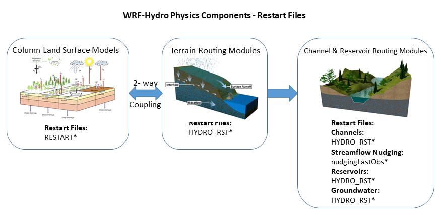
Figure A13. Overview of restart files for the various model physics components.
A13.1 RESTART_MP File Variable Table
Note
Noah-MP restarts are written in subroutine lsm_restart() in module_NoahMP_hrldas_driver.F.
Noah-MP variables are defined in subroutine noahmplsm() in module_sf_noahmpdrv.F
\(RESTART\_MP\) file variable descriptions
Variable name |
Description |
Units |
|---|---|---|
ACMELT |
accumulated melting water out of snow bottom |
\(mm\) |
ACSNOW |
accumulated snowfall on grid |
\(mm\) |
ALBOLD |
snow albedo at last time step (-) |
|
AREAXY |
(in the file but not used by the model) |
|
CANICE |
Canopy ice water content / canopy-intercepted ice |
\(mm\) |
CANLIQ |
Canopy liquid water content / canopy-intercepted liquid water |
\(mm\) |
CH |
Sensible heat exchange coefficient |
|
CM |
Momentum drag coefficient |
|
DEEPRECHXY |
soil moisture below the bottom of the column |
\(m^3/m^3\) |
EAH |
canopy air vapor pressure |
\(Pa\) |
EQZWT |
(in the file but not used by the model) |
|
FASTCP |
short-lived carbon in shallow soil |
\(g/m^2\) |
FDEPTHXY |
(in the file but not used by the model) |
|
FWET |
Wetted or snowed fraction of canopy |
\(fraction\) |
GVFMAX |
annual maximum in vegetation fraction |
|
GVFMIN |
annual minimum in vegetation fraction |
|
ISNOW |
Number of snow layers |
\(count\) |
LAI |
leaf area index |
|
LFMASS |
Leaf mass |
\(g/m^2\) |
PEXPXY |
(in the file but not used by the model) |
|
QRFSXY |
Stem mass |
\(g/m^2\) |
QRFXY |
(in the file but not used by the model) |
|
QSFC |
bulk surface specific humidity |
|
QSLATXY |
Stable carbon in deep soil |
\(g/m^2\) |
QSNOW |
snowfall rate on the ground |
\(mm/s\) |
QSPRINGSXY |
Mass of wood and woody roots |
\(g/m^2\) |
QSPRINGXY |
(in the file by not used by the model) |
|
RECHXY |
recharge to the water table (diagnostic) |
\(m^3/m^3\) |
RIVERBEDXY |
(in the file but not used by the model) |
|
RIVERCONDXY |
(in the file but not used by the model) |
|
RTMASS |
mass of fine roots |
\(g/m^2\) |
SAI |
stem area index |
|
SFCRUNOFF |
Accumulatetd surface runoff |
\(mm\) |
SH2O |
volumetric liquid soil moisture |
\(m^3/m^3\) |
SMC |
Volumetric Soil Moisture |
\(m^3/m^3\) |
SMCWTDXY |
soil moisture below the bottom of the column |
\(m^3/m^3\) |
SMOISEQ |
volumetric soil moisture |
\(m^3/m^3\) |
SNEQV |
Snow water equivalent |
\(kg/m^2\) |
SNEQVO |
snow mass at last time step |
\(mm\) |
SNICE |
snow layer ice |
\(mm\) |
SNLIQ |
Snow layer liquid water |
\(mm\) |
SNOWH |
Snow depth |
\(m\) |
SNOW_T |
snow temperature |
\(K\) |
SOIL_T |
Soil Temperature on NSOIL layers |
\(K\) |
STBLCP |
Stable carbon in deep soil |
\(g/m^2\) |
STMASS |
stem mass |
\(g/m^2\) |
TAH |
Canopy Air Temperature |
\(K\) |
TAUSS |
snow age factor |
|
TG |
Ground Temperature |
\(K\) |
TV |
Canopy Temperature |
\(K\) |
UDRUNOFF |
Accumulated underground runoff” |
\(mm\) |
WA |
Water in aquifer relative to reference level |
\(kg/m^2\) |
WOOD |
Mass of wood and woody roots |
\(g/m^2\) |
WSLAKE |
lake water storage |
\(mm\) |
WT |
Water in aquifer and saturated soil |
\(kg/m^2\) |
ZSNSO |
Snow layer depths from snow surface |
\(m\) |
ZWT |
water table depth |
\(m\) |
VEGFRA |
Vegetation fraction |
|
ACCPRCP |
Accumulated precipitation |
\(mm\) |
ACCECAN |
Accumulated canopy evaporation |
\(mm\) |
ACCEDIR |
Accumulated direct soil evaporation |
\(mm\) |
ACCETRAN |
Accumulated transpiration |
\(mm\) |
SMOISEQ |
volumetric soil moisture |
\(m^3/m^3\) |
A13.2 HYDRO_RST File Variable Table
Note
The variables are written to the \(HYDRO_RST\) file in the subroutine of
RESTART_OUT_nc in the Routing/module_HYDRO_io.F90. The tables below
contain all the information on the dimensions and variables in the Hydro
RESTART file (\(HYDRO\_RST\)).
Dimension |
Description |
It is written |
|---|---|---|
depth |
Number of soil layers |
|
ix |
Number of columns in the coarse grid (LSM) |
|
iy |
Number of rows in the coarse grid (LSM) |
|
ixrt |
Number of columns in the fine grid (hydro) |
|
iyrt |
Number of rows in the fine grid (hydro) |
|
links |
Number of links/reaches |
|
basns |
Number of basins for the groundwater/baseflow modeling |
Only if |
lakes |
Number of lakes |
Only if the lake routing is turned on |
Variable name |
Description |
# Dimensions (not including time) |
Resolution |
Units |
|---|---|---|---|---|
cvol |
volume of stream in cell |
1 |
fine/link |
\(m^3\) |
hlink |
stream stage |
1 |
fine/link |
\(m\) |
infxsrt |
infiltration excess water |
2 |
coarse |
\(mm\) |
infxswgt |
weights for disaggregation of infxsrt |
2 |
fine |
- |
qbdryrt |
accumulated value of the boundary flux |
2 |
fine |
\(mm\) |
qlink1 |
stream flow in to cell/reach |
1 |
fine/link |
\(m^3/s\) |
qlink2 |
stream flow out of cell/reach |
1 |
fine/link |
\(m^3/s\) |
qstrmvolrt |
Accumulated depth of stream channel inflow |
2 |
fine |
\(mm\) |
sfcheadrt |
surface head on the coarse grid |
2 |
coarse |
\(mm\) |
sfcheadsubrt |
surface head on the routing grid |
2 |
fine |
\(mm\) |
sh2owgt |
weights for disaggregation of total soil moisture (smc) |
3 |
fine |
- |
sh2ox |
liquid soil moisture |
3 |
coarse |
\(m^3/m^3\) |
smc |
total liq+ice soil moisture. |
3 |
coarse |
\(m^3/m^3\) |
soldrain |
soil drainage |
2 |
coarse |
\(mm\) |
stc |
soil temperature |
3 |
coarse |
\(K\) |
lake_inflort |
lake inflow |
2 |
fine |
\(mm\) |
resht |
water surface elevation |
1 |
link |
\(m\) |
qlakeo |
outflow from lake used in diffusion scheme |
1 |
link |
\(m^3/s\) |
qlakei |
lake inflow |
numLakes |
link |
\(m^3/s\) |
z_gwsubbas |
depth in ground water bucket |
1 |
link |
\(m\) |
A14. Streamflow Nudging
Figure A14.1 Below is an example netCDF header nudging time slice observation file containing 2 gages. The command ncdump -h was used to produce this header information.
netcdf 2013-06-01_21:45:00.15min.usgsTimeSlice {
dimensions:
   stationIdStrLen = 15 ;
   stationIdInd = UNLIMITED ; // (2 currently)
   timeStrLen = 19 ;
variables:
   char stationId(stationIdInd, stationIdStrLen) ;
      stationId:long_name = "USGS station identifier of length 15" ;
   char time(stationIdInd, timeStrLen) ;
      time:units = "UTC" ;
      time:long_name = "YYYY-MM-DD_HH:mm:ss UTC" ;
   float discharge(stationIdInd) ;
      discharge:units = "m^3/s" ;
      discharge:long_name = "Discharge.cubic_meters_per_second" ;
   short discharge_quality(stationIdInd) ;
      discharge_quality:units = "-" ;
      discharge_quality:long_name = "Discharge quality 0 to 100 to be scaled by 100." ;
   float queryTime(stationIdInd) ;
      queryTime:units = "seconds since 1970-01-01 00:00:00 local TZ" ;
// global attributes:
      :fileUpdateTimeUTC = "2017-08-25_17:24:22" ;
      :sliceCenterTimeUTC = "2013-06-01_21:45:00" ;
      :sliceTimeResolutionMinutes = "15" ;
}
Figure A14.2: Below is an example \(nudgingParams.nc\) file containing parameters for 3 gages. The command ncdump -h was used to create this header information.
netcdf nudgingParams {
dimensions:
   stationIdInd = UNLIMITED ; // (3 currently)
   monthInd = 12 ;
   threshCatInd = 2 ;
   threshInd = 1 ;
   stationIdStrLen = 15 ;
variables:
   float G(stationIdInd) ;
      G:units = "-" ;
      G:long_name = "Amplitude of nudging" ;
   float R(stationIdInd) ;
      R:units = "meters" ;
      R:long_name = "Radius of influence in meters" ;
   float expCoeff(stationIdInd, monthInd, threshCatInd) ;
      expCoeff:units = "minutes" ;
      expCoeff:long_name = "Coefficient b in denominator e^(-dt/b)" ;
   float qThresh(stationIdInd, monthInd, threshInd) ;
      qThresh:units = "m^3/s" ;
      qThresh:long_name = "Discharge threshold category" ;
   char stationId(stationIdInd, stationIdStrLen) ;
      stationId:units = "-" ;
      stationId:long_name = "USGS station identifer" ;
   float tau(stationIdInd) ;
      tau:units = "minutes" ;
      tau:long_name = "Time tapering parameter half window size in minutes" ;
}
A15. National Water Model (NWM) Configuration
It is important to note here that the community WRF-Hydro modeling system is currently the actual underlying modeling architecture that is used in the NOAA National Water Model. This means that the community WRF-Hydro model code is configurable into the National Water Model configurations that runs in operations at the National Center for Environmental Prediction (NCEP).
“The NWM is an hourly cycling uncoupled analysis and forecast system that provides streamflow for 2.7 million river reaches and other hydrologic information on 1km and 250m grids. The model provides complementary hydrologic guidance at current NWS River Forecast Center (RFC) river forecast locations and significantly expanded guidance coverage and type in underserved locations.
The NWM ingests forcing from a variety of sources including Multi-Radar Multi-Sensor (MRMS) radar-gauge observed precipitation data and High-Resolution Rapid Refresh (HRRR), Rapid Refresh (RAP), Global Forecast System (GFS) and Climate Forecast System (CFS) Numerical Weather Prediction (NWP) forecast data. USGS real-time streamflow observations are assimilated and all NWM configurations benefit from the inclusion of ~5500 reservoirs. The core of the NWM system is the National Center for Atmospheric Research (NCAR)-supported community Weather Research and Forecasting (WRF)-Hydro hydrologic model. WRF-Hydro is configured to use the Noah Multi-
Parameterization (Noah-MP) Land Surface Model (LSM) to simulate land surface processes. Separate water routing modules perform diffusive wave surface routing and saturated subsurface flow routing on a 250m grid, and Muskingum-Cunge channel routing down NHDPlusV2 stream reaches. River analyses and forecasts are provided across a domain encompassing the continental U.S. and hydrologically-contributing areas, while land surface output is available on a larger domain that extends beyond the continental U.S. into Canada and Mexico (roughly from latitude 19N to 58N). In addition, NWM forcing datasets are provided on this domain at a resolution of 1km.”
Excerpt from NOUS41 KWBC 061735 PNSWSH NWS Office of Science and Technology Integration
For more information regarding the operational configuration, input, and output data of the National Water Model see the Office of Water Prediction website: http://water.noaa.gov/about/nwm and the Open Commons Consortium Environmental Data Commons website: http://edc.occ-data.org/nwm/.
The NWM/WRF-Hydro modeling system suite of tools for data preparation, evaluation, and calibration. is continually under development and will be rolled out to the community as each tool becomes finalized with supporting documentation for public usage. To be notified when tools become available please subscribe to the WRF-Hydro email list https://ral.ucar.edu/projects/wrf_hydro/subscribe.
The figures below illustrate the physics permutations available in the WRF-Hydro framework and the Noah-MP land surface model as well as the current National Water Model configuration as of March 2018, the NWM ecosystem and suite of tools and sample NWM configuration namelists.

Figure A15.1 Illustration of WRF-Hydro physics permutations and those used in the current configuration of the National Water Model (NWM).
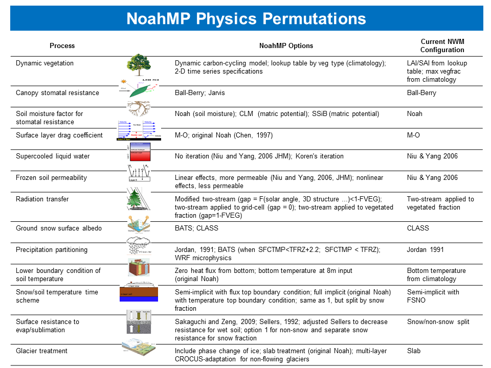
Figure A15.2. Illustration of Noah-MP physics permutations and those used in the configuration of the National Water Model (NWM)

Figure A15.3 National Water Model/WRF-Hydro Modeling System Ecosystem and Suite of Tools.
There are different NWM configurations that run operationally. The full list of the configurations and their specifics can be found at https://water.noaa.gov/about/nwm. Below we provide the namelists for the Standard Analysis configuration (self-cycling with 3-hour look-back, used to initialize CONUS short- and medium-range forecasts) as the sample namelists. Note that the name of the files are different from the conventions used throughout this documentation and they match with the name of the files in operation (A subset of the model parameter files used by the operational implementation of the NWM is available on NWM website). The namelists for all the configurations are also being distributed with the model code.
Below are sample NWM configuration namelists for both the LSM (NoahMP) and WRF-Hydro:
\(namelist.hrldas\) (sample NWM configuration)
&NOAHLSM_OFFLINE
HRLDAS_SETUP_FILE = "./DOMAIN/wrfinput_d01_1km.nc"
INDIR = "./forcing"
SPATIAL_FILENAME = "./DOMAIN/soil_veg_properties_ASM.nc"
OUTDIR = "./"
START_YEAR = 2018
START_MONTH = 06
START_DAY = 01
START_HOUR = 00
START_MIN = 00
RESTART_FILENAME_REQUESTED = "RESTART.2018060100_DOMAIN1"

! Specification of simulation length in days OR hours
!KDAY = 1
KHOUR = 3

! Physics options (see the documentation for details)
DYNAMIC_VEG_OPTION = 4
CANOPY_STOMATAL_RESISTANCE_OPTION = 1
BTR_OPTION = 1
RUNOFF_OPTION = 3
SURFACE_DRAG_OPTION = 1
FROZEN_SOIL_OPTION = 1
SUPERCOOLED_WATER_OPTION = 1
RADIATIVE_TRANSFER_OPTION = 3
SNOW_ALBEDO_OPTION = 1
PCP_PARTITION_OPTION = 1
TBOT_OPTION = 2
TEMP_TIME_SCHEME_OPTION = 3
GLACIER_OPTION = 2
SURFACE_RESISTANCE_OPTION = 4

! Timesteps in units of seconds
FORCING_TIMESTEP = 3600
NOAH_TIMESTEP = 3600
OUTPUT_TIMESTEP = 3600

! Land surface model restart file write frequency
RESTART_FREQUENCY_HOURS = 1

! Split output after split_output_count output times.
SPLIT_OUTPUT_COUNT = 1

! Soil layer specification
NSOIL=4
soil_thick_input(1) = 0.10
soil_thick_input(2) = 0.30
soil_thick_input(3) = 0.60
soil_thick_input(4) = 1.00

! Forcing data measurement height for winds, temp, humidity
ZLVL = 10.0

! Restart file format options
rst_bi_in = 0 !0: use netcdf input restart file
      !1: use parallel io for reading multiple restart files (1 per core)
rst_bi_out = 0 !0: use netcdf output restart file
      !1: use parallel io for outputting multiple restart files (1 per core)
/

&WRF_HYDRO_OFFLINE
! Specification of forcing data: 1=HRLDAS-hr format, 2=HRLDAS-min
! format, 3=WRF, 4=Idealized, 5=Ideal w/ spec. precip,
! 6=HRLDAS-hr format w/ spec. precip, 7=WRF w/ spec. precip
FORC_TYP = 2

/
\(hydro.namelist\) (sample NWM configuration)
&HYDRO_nlist

!!!! ---------------------- SYSTEM COUPLING -----------------------
!!!!

! Specify what is being coupled: 1=HRLDAS (offline Noah-LSM), 2=WRF, 3=NASA/LIS, 4=CLM
sys_cpl = 1

!!!! ------------------- MODEL INPUT DATA FILES -------------------
!!!!

! Specify land surface model gridded input data file (e.g.: "geo_em.d01.nc")
GEO_STATIC_FLNM = "./DOMAIN/geo_em.d01_1km.nc"

! Specify the high-resolution routing terrain input data file (e.g.: "Fulldom_hires.nc")
GEO_FINEGRID_FLNM = "./DOMAIN/Fulldom_hires_netcdf_250m.nc"

! Specify the spatial hydro parameters file (e.g.: "hydro2dtbl.nc")
! If you specify a filename and the file does not exist, it will becreated for you.
HYDROTBL_F = "./DOMAIN/HYDRO_TBL_2D.nc"

! Specify spatial metadata file for land surface grid. (e.g.: "GEOGRID_LDASOUT_Spatial_Metadata.nc")
LAND_SPATIAL_META_FLNM = "./DOMAIN/WRF_Hydro_NWM_geospatial_data_template_land_GIS.nc"

! Specify the name of the restart file if starting from restart...comment out with '!' if not...
RESTART_FILE = 'HYDRO_RST.2018-06-01_00:00_DOMAIN1'

!!!! --------------------- MODEL SETUP OPTIONS --------------------
!!!!

! Specify the domain or nest number identifier...(integer)
IGRID = 1

! Specify the restart file write frequency...(minutes)
! A value of -99999 will output restarts on the first day of the month only.
rst_dt = 60

! Reset the LSM soil states from the high-res routing restart file (1=overwrite, 0=no overwrite)
! NOTE: Only turn this option on if overland or subsurface rotuing is active!
rst_typ = 1

! Restart file format control

rst_bi_in = 0 !0: use netcdf input restart file (default)
!1: use parallel io for reading multiple restart files, 1 per core

rst_bi_out = 0 !0: use netcdf output restart file (default)
!1: use parallel io for outputting multiple restart files, 1 per core

! Restart switch to set restart accumulation variables to 0 (0=no reset, 1=yes reset to 0.0)
RSTRT_SWC = 1

! Specify baseflow/bucket model initialization...(0=cold start from table, 1=restart file)
GW_RESTART = 1

!!!! -------------------- MODEL OUTPUT CONTROL --------------------
!!!!

! Specify the output file write frequency...(minutes)
out_dt = 60

! Specify the number of output times to be contained within each output history file...(integer)
! SET = 1 WHEN RUNNING CHANNEL ROUTING ONLY/CALIBRATION SIMS!!!
! SET = 1 WHEN RUNNING COUPLED TO WRF!!!
SPLIT_OUTPUT_COUNT = 1

! Specify the minimum stream order to output to netcdf point file...(integer)
! Note: lower value of stream order produces more output.
order_to_write = 1

! Flag to turn on/off new I/O routines: 0 = deprecated output routines (use when running with Noah LSM),
! 1 = with scale/offset/compression, ! 2 = with scale/offset/NO compression,
! 3 = compression only, 4 = no scale/offset/compression (default)
io_form_outputs = 2

! Realtime run configuration option:
! 0=all (default), 1=analysis, 2=short-range, 3=medium-range, 4=long-range, 5=retrospective,
! 6=diagnostic (includes all of 1-4 outputs combined)
io_config_outputs = 1

! Option to write output files at time 0 (restart cold start time): 0=no, 1=yes (default)
t0OutputFlag = 1

! Options to output channel & bucket influxes. Only active for UDMP_OPT=1.
! Nonzero choice requires that out_dt above matches NOAH_TIMESTEP in namelist.hrldas.
! 0=None (default), 1=channel influxes (qSfcLatRunoff, qBucket)
! 2=channel+bucket fluxes (qSfcLatRunoff, qBucket, qBtmVertRunoff_toBucket)
! 3=channel accumulations (accSfcLatRunoff, accBucket) \*\*NOT TESTED\*\*

output_channelBucket_influx = 2

! Output netcdf file control
CHRTOUT_DOMAIN = 1 ! Netcdf point timeseries output at all channel points (1d)
                   ! 0 = no output, 1 = output

CHANOBS_DOMAIN = 0 ! Netcdf point timeseries at forecast points or gage points (defined in Routelink)
! 0 = no output, 1 = output at forecast points or gage points.

CHRTOUT_GRID = 0 ! Netcdf grid of channel streamflow values (2d)
                 ! 0 = no output, 1 = output
                 ! NOTE: Not available with reach-based routing

LSMOUT_DOMAIN = 0 ! Netcdf grid of variables passed between LSM and routing components (2d)
                  ! 0 = no output, 1 = output
                  ! NOTE: No scale_factor/add_offset available

RTOUT_DOMAIN = 1 ! Netcdf grid of terrain routing variables on routing grid (2d)
                 ! 0 = no output, 1 = output

output_gw = 0 ! Netcdf GW output, 0 = no output, 1 = output
outlake = 1 ! Netcdf grid of lake values (1d), 0 = no output, 1 = output

frxst_pts_out = 0 ! ASCII text file of forecast points or gage points (defined in Routelink)
                  ! 0 = no output, 1 = output

!!!! ------------ PHYSICS OPTIONS AND RELATED SETTINGS ------------
!!!!

! Specify the number of soil layers (integer) and the depth of the bottom of each layer... (meters)
! Notes: In Version 1 of WRF-Hydro these must be the same as in the namelist.input file.
! Future versions will permit this to be different.
NSOIL=4
ZSOIL8(1) = -0.10
ZSOIL8(2) = -0.40
ZSOIL8(3) = -1.00
ZSOIL8(4) = -2.00

! Specify the grid spacing of the terrain routing grid...(meters)
DXRT = 250.0

! Specify the integer multiple between the land model grid and the terrain routing grid...(integer)
AGGFACTRT = 4

! Specify the channel routing model timestep...(seconds)
DTRT_CH = 300

! Specify the terrain routing model timestep...(seconds)
DTRT_TER = 10

! Switch to activate subsurface routing...(0=no, 1=yes)
SUBRTSWCRT = 1

! Switch to activate surface overland flow routing...(0=no, 1=yes)
OVRTSWCRT = 1

! Specify overland flow routing option: 1=Steepest Descent (D8) 2=CASC2D (not active)
! NOTE: Currently subsurface flow is only steepest descent
rt_option = 1

! Switch to activate channel routing...(0=no, 1=yes)
CHANRTSWCRT = 1

! Specify channel routing option: 1=Muskingam-reach, 2=Musk.-Cunge-reach, 3=Diff.Wave-gridded
channel_option = 2

! Specify the reach file for reach-based routing options (e.g.: "Route_Link.nc")
route_link_f = "./DOMAIN/RouteLink_NHDPLUS.nc"

! If using channel_option=2, activate the compound channel formulation? (Default=.FALSE.)
compound_channel = .TRUE.

! Specify the lake parameter file (e.g.: "LAKEPARM.nc").
! Note REQUIRED if lakes are on.
route_lake_f = "./DOMAIN/LAKEPARM_NHDPLUS.nc"

! Switch to activate baseflow bucket model...(0=none, 1=exp. bucket, 2=pass-through)
GWBASESWCRT = 1

! Groundwater/baseflow 2d mask specified on land surface model grid (e.g.: "GWBASINS.nc")
! Note: Only required if baseflow model is active (1 or 2) and UDMP_OPT=0.
gwbasmskfil = "./DOMAIN/GWBASINS.nc"

! Groundwater bucket parameter file (e.g.: "GWBUCKPARM.nc")
GWBUCKPARM_file = "./DOMAIN/GWBUCKPARM_CONUS.nc"

! User defined mapping, such NHDPlus: 0=no (default), 1=yes
UDMP_OPT = 1

! If on, specify the user-defined mapping file (e.g.: "spatialweights.nc")
udmap_file = "./DOMAIN/spatialweights_250m_all_basins.nc"

/

&NUDGING_nlist

! Path to the "timeslice" observation files.
timeSlicePath = "./nudgingTimeSliceObs/"
nudgingParamFile = "./DOMAIN/nudgingParams.nc"

! Nudging restart file = "nudgingLastObsFile"
! nudgingLastObsFile defaults to '', which will look for nudgingLastObs.YYYY-mm-dd_HH:MM:SS.nc
! \*\*AT THE INITALIZATION TIME OF THE RUN\*\*. Set to a missing file to use no restart.

!nudgingLastObsFile = '/a/nonexistent/file/gives/nudging/cold/start'

!! Parallel input of nudging timeslice observation files?
readTimesliceParallel = .TRUE.

! temporalPersistence defaults to true, only runs if necessary params present.
temporalPersistence = .TRUE.

! The total number of last (obs, modeled) pairs to save in nudgingLastObs for
! removal of bias. This is the maximum array length. (This option is active when persistBias=FALSE)
! (Default=960=10days @15min obs resolution, if all the obs are present and longer if not.)
nLastObs = 480

! If using temporalPersistence the last observation persists by default.
! This option instead persists the bias after the last observation.
persistBias = .TRUE.

! AnA (FALSE) vs Forecast (TRUE) bias persistence.
! If persistBias: Does the window for calculating the bias end at
! model init time (=t0)?
! FALSE = window ends at model time (moving),
! TRUE = window ends at init=t0(fcst) time.
! (If commented out, Default=FALSE)
! Note: Perfect restart tests require this option to be .FALSE.
biasWindowBeforeT0 = .FALSE.

! If persistBias: Only use this many last (obs, modeled) pairs. (If Commented out, Default=-1*nLastObs)
! > 0: apply an age-based filter, units=hours.
! = 0: apply no additional filter, use all available/usable obs.
! < 0: apply an count-based filter, units=count
maxAgePairsBiasPersist = 3

! If persistBias: The minimum number of last (obs, modeled) pairs, with age less than
! maxAgePairsBiasPersist, required to apply a bias correction. (default=8)
minNumPairsBiasPersist = 1

! If persistBias: give more weight to observations closer in time? (default=FALSE)
invDistTimeWeightBias = .TRUE.

! If persistBias: "No constructive interference in bias correction?", Reduce the bias adjustment
! when the model and the bias adjustment have the same sign relative to the modeled flow at t0?
! (default=FALSE)
! Note: Perfect restart tests require this option to be .FALSE.
noConstInterfBias = .TRUE.

/
A16. The Crocus Glacier Model
Crocus is an energy and mass transfer snowpack model, initially developed for avalanche forecasting (Brun et al., 1989, 1992). The version that was implemented into the French SURFEX model V8.0 (Vionnet et al., 2012) is being used here. This version has several updates from older versions of Crocus, such as the impacts of wind drift.
The Crocus snowpack model is a multilayered, physically based snow model that explicitly calculates snow grain properties in each snow layer and how these properties change over time. The grain properties of dendricity, sphericity and size are prognosed in Crocus through metamorphism, compaction and impacts of wind drift. Furthermore, the snow albedo is calculated based on the snow grain properties from the top 3cm of the snowpack (Vionnet et al., 2012) and is calculated in three spectral bands (0.3-0.8, 0.8-1.5 and 1.5-2.5 \(\mu m\)). Impurities in aging snow are parameterized in the UV and visible spectral band (0.3-0.8 \(\mu m\)) from the age of the snow, with a time constant of 60 days. See Vionnet et al. (2012) for a detailed description of the albedo calculations. The albedo over ice is constant in all spectral bands and is 0.38, 0.23 and 0.08 for the spectral bands 0.3-0.8, 0.8-1.5 and 1.5-2.5 \(\mu m\). The sensible and latent heat are parameterized with an effective roughness length over snow and ice (see Vionnet et al. (2012) for further details).
In the Crocus model, it is possible to divide the snow into a user-defined maximum numbers of dynamically evolving layers. As new snow is accumulated, a new active layer is added. As different snow layers become similar (based upon the number of user-set layers, the thickness of the snow layers and the snow grain characteristics), these snow layers will merge into single snow layers.
The Crocus module is added to the Noah-MP land surface model in WRF-Hydro to act as a glacier mass balance model (Eidhammer et al. 2021). Over designated glacier grid points, the Crocus snow model represents both snow and ice, while outside of the designated glacier grid points, the regular three-layer snow model in Noah-MP is used. Since the current Crocus implementation in WRF-Hydro only acts over designated glacier grid points, we follow Gerbaux et al. (2005) and assume that the temperatures at the bottom of the glacier and the ground below are both at \(0^\circ C\). Note that we have not yet incorporated fluxes between the glacier and the ground below; thus, there is a constant temperature boundary condition.
Both Crocus and Noah-MP (for the non-glacier grid points) output runoff from snowmelt (and precipitation). This runoff is provided to the terrain routing models in WRF-Hydro.
Note that the implementation of Crocus as a glacier mass balance model does not address glacier movement (i.e., plastic flow) nor lateral wind (re)distribution of snow. However, there are two options for including impacts on the snow due to wind. One of the options impacts the snow density during blowing snow events (Brun et al., 1997). This option is important in polar environments (Brun et al., 1997). The other option is the sublimation due to snow drift, which was implemented by Vionnet et al. (2012) and which is in the Crocus version that is used in this study.
As implemented, if the glacier completely melts over a user-defined glacier grid point, the original Noah-MP module is used from this point on. Therefore, as currently implemented, the glacier cannot grow horizontally in extent; it can only decrease in extent, as no dynamic response of the ice mass is included in the model. Over short model time periods, the lack of increase in glacier extent might impact a few grid points at the edges of the glacier. However, given the expected increase in temperature in the future, we do not expect that limiting glacier horizontal growth will have a major impact over most studied glaciers as most are likely to decrease in mass and extent.
Running WRF-Hydro / Glacier
Below is a description on how to run with Crocus as a glacier model. There are
only a few namelist options that needs to be added in namelist.hrldas:
&CROCUS_nlist
crocus_opt = 1      ! 0 model is off, 1 model is on
act_lev = 40        ! 1-50, 20-40 normal options
/
The initialization file wrfinput needs two additional fields to be defined:
glacierglacier_thickness
The field glacier should have the value of 1 over glacier gridpoints. The
glacier field can be provided by the user, or the user can use the glacier
category from IVGTYP.
Here is an example how to generate initial glacier fields for an “ideal”
simulation, with homogeneous glacier thickness layer. In this case,
IVGTYP=24 represents glaciers:
ncap2 -O -s 'glacier=IVGTYP' wrfinput.nc wrfinput.nc
ncap2 -O -s 'where(glacier!=24) glacier=0' wrfinput.nc wrfinput.nc
ncap2 -O -s 'where(glacier==24) glacier=1' wrfinput.nc wrfinput.nc
To create a 300 m thick glacier:
ncap2 -O -s 'glacier_thickness=glacier*300' wrfinput.nc wrfinput.nc
At initialization, it is assumed that the glacier consists of only ice, and the
density is that of pure ice (\(900 \frac{kg}{m^3}\)). Within the user-defined maximum
layers (act_lev) the glacier is initialized with all the layers having the same
assumed density and snow grain properties. As new snow accumulates during the
simulations, the layers representing the glacier will start to merge since all
layers contain the initialized ice.
Crocus outputs
Dimension |
Explanation |
Units |
|
|---|---|---|---|
PSNOWSWE |
3D |
Snow water equivalent |
\(kg/m^2\) |
PSNOWTEMP |
3D |
Glacier temperature |
\(K\) |
PSNOWALB |
2D |
Albedo |
\(-\) |
PSNOWTHRUFAL |
2D |
Surface runoff rate |
\(kg/m^2/s\) |
PSNOWHEIGHT |
2D |
Total glacier thickness |
\(m\) |
PSNOWTOTSWE |
2D |
Total glacier snow water equivalent |
\(kg/m^2\) |
PSNOWGRAN1 |
3D |
Snow grain parameter 1 |
\(-\) |
PSNOWGRAN2 |
3D |
Snow grain parameter 2 |
\(-\) |
PSNOWDZ |
3D |
Thickness of snow/ice layers |
\(m\) |
PSNOWHIST |
3D |
Snow grain historical parameter |
\(-\) |
PSNOWLIQ |
3D |
Liquid content |
\(kg/m^2\) |
PSNOWRHO |
3D |
Snow/ice density |
\(kg/m^3\) |
FLOW_ICE |
2D |
Accumulated surface runoff from ice surface |
\(kg/m^2\) (or \(mm\)) |
FLOW_SNOW |
2D |
Accumulated surface runoff from snow surface |
\(kg/m^2\) (or \(mm\)) |
Note
Note on other WRF-Hydro outputs: The following outputs are informed
from both Noah-MP and Crocus. Over glacier gridpoints, the outputs
are informed from Crocus: ACCET, ALBEDO, SNOWEQV, SNOWH
and ACSNOWM.
Currently there are no namelist options to change parameter values.
Several important parameters that can be modified can be found in:
src/Land_models/NoahMP/phys/surfex/modd_snow_par.F90